Three route observations: one lower mapped count, two unchanged.
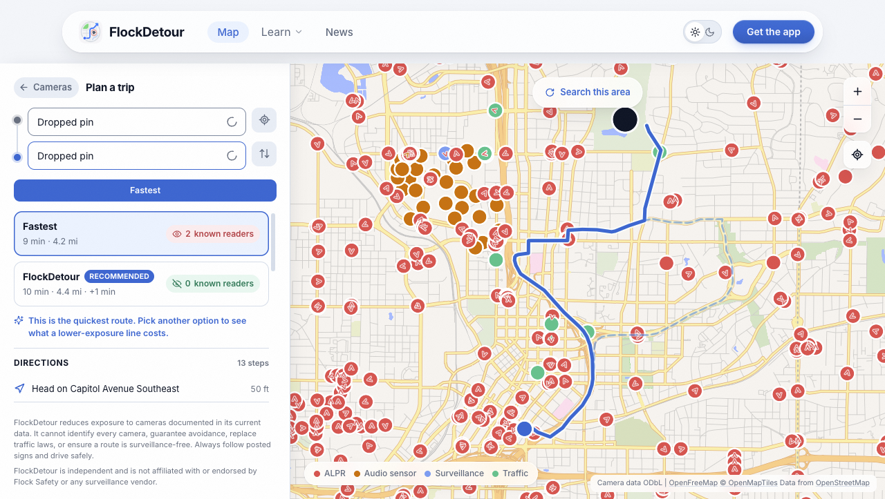
In three October 3, 2026 FlockDetour software observations, the Atlanta example reduced estimated mapped encounters from two to zero for 46 additional estimated seconds; Tampa and Washington returned the same one-encounter route, so these results do not establish a general avoidance advantage.
What we actually ran
FlockDetour, the product's publisher, selected three pairs of non-personal public-landmark reference coordinates. We made one request for each of the fastest, balanced and minimize-ALPR modes through the production website's route endpoint on October 3, 2026, between 14:30:28 and 14:30:49 UTC. All nine requests returned routes from Valhalla. The website applied its existing camera filters and 20% maximum-detour request setting.
We also entered the same coordinates in the FlockHopper and DeFlock public web planners that day. We retained their displayed default settings, including the visible 246-foot camera-distance setting in FlockHopper with directional zones enabled. These settings and exposure calculations are not equivalent to FlockDetour's, so their camera counts cannot be treated as measurements by one common instrument.
Times below are software estimates, not timed drives or live-traffic predictions. The reference pins were not checked as vehicle entrances. No road-sign inspection, physical driving test or mobile-app version comparison was performed. The three trips were a small demonstration set, not a statistically representative commute sample.
The same public coordinates in each planner
Tampa: City Hall reference pin, 27.9477, −82.4573, to Raymond James Stadium reference pin, 27.9759, −82.5033.
Atlanta: Georgia State Capitol reference pin, 33.7490, −84.3880, to Piedmont Park southwest entrance reference pin, 33.7856, −84.3737.
Washington: Union Station reference pin, 38.8970, −77.0064, to Lincoln Memorial approach reference pin, 38.8893, −77.0488.
Entering the same coordinates controls the requested endpoints. Each provider can still snap a pin to a different road and choose a different route. For a stronger comparison, inspect the returned geometry, endpoint snapping and road restrictions before comparing time or exposure.
Atlanta improved in the model; Tampa and Washington did not
Tampa: the fastest result was 9,282 metres and 11 minutes 36 seconds, with one estimated mapped encounter. Balanced and minimize-ALPR returned the same geometry and count. The server reported that it had not found a lower-exposure route within its search constraints. That is a result about this search, not proof that every possible alternative was examined.
Atlanta: the fastest result was 6,705 metres and 9 minutes 26 seconds, with two estimated mapped encounters. Both privacy modes selected 7,116 metres and 10 minutes 12 seconds, with zero estimated mapped encounters: 411 additional metres and 46 additional estimated seconds. The rendered website also showed the comparison, rounded to 9 versus 10 minutes and two versus zero known readers.
Washington: all three modes selected 6,218 metres and 7 minutes 44 seconds, with one estimated mapped encounter. Both privacy-mode responses again reported no lower-exposure route found within their search constraints.
Zero is a model result against documented camera records. It does not mean no cameras exist, no reader could capture a plate or the trip is surveillance-free. We retained the unsuccessful cases alongside the Atlanta result so the example cannot be mistaken for a universal benefit.
View the dated Atlanta result screenshot · Try the public FlockDetour planner
What FlockHopper and DeFlock displayed
The two public planners displayed matching results for these three final coordinate pairs. In Tampa, each showed a direct route of 4.8 miles and 7 minutes with two camera estimates, and a privacy route of 4.6 miles and 8 minutes with zero. In Atlanta, each showed 3.2 miles and 5 minutes with one, versus 3.2 miles and 6 minutes with zero. In Washington, each showed 3.0 miles and 5 minutes with one, versus 3.8 miles and 7 minutes with one.
Those are rounded values read from the interfaces, not independently rescored routes. DeFlock's route page identifies Maps by OpenRoad Labs and links to FlockHopper navigation; this sample should not be described as two independently validated routing engines. We did not establish exact software versions or equivalent road-costing settings.
The different direct-route distances and times are a reason to investigate route geometry and provider settings. They do not support a claim that FlockDetour is faster, more accurate or better at avoidance. A publishable superiority claim would require a defined common scoring method and validation beyond these screenshots.
A stronger benchmark needs common evidence
Export every candidate geometry, inspect the snapped start and destination, and score all candidates against one dated camera dataset under one published distance-and-direction rule. Record road restrictions and provider settings. Repeat the same preselected trips, including failures, before summarising results across a city.
A physical drive can check signs, turn instructions and practical route quality, but cannot prove that undocumented readers are absent. Until that work is done, use these observations to understand a tradeoff and identify tests to improve—not to advertise guaranteed avoidance or a competitive win.
Tampa's map evidence and limits · Atlanta's map evidence and limits
Questions people ask
Did FlockDetour avoid every camera on the Atlanta trip?
Was a lower-camera route found for every tested trip?
Do these results prove one app beats DeFlock or FlockHopper?
Related guides
DeFlock, FlockHopper and FlockDetour compared · Tampa's map has 234 ALPR records. That is not a police inventory. · Atlanta's camera map and its police audit measure different things. · All guides · Live camera map · Get the app
Sources
- FlockDetour public planner: production route responses observed October 3, 2026 at 14:30 UTC; Atlanta comparison also inspected in the rendered web interface
- FlockHopper web planner: same coordinate pairs entered in the public UI October 3; rounded displayed estimates, not raw geometry or a driving test
- DeFlock web planner: same coordinate pairs entered in the public UI October 3; map footer identifies OpenRoad Labs
- FlockDetour camera sources: source attribution and import context; map data is community reported and incomplete
FlockDetour is independent and is not affiliated with or endorsed by Flock Safety or any surveillance vendor.